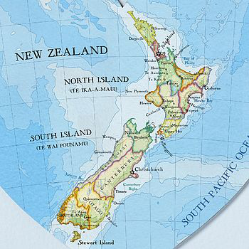
Sample using Wsg84 [4326] in New Zealand:
radius[6378137.0]: in
meters (Wsg84)
From: North/Western point of the North Island.
point_from: MakePoint(172.677712,-34.426461,4326)
To: Southern most point of the South Island.
point_to: MakePoint(167.836789,-46.969656,4326)
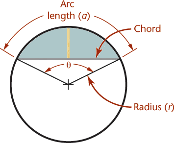
SELECT
GeodesicArcLength(point_from,point_to,
1);
1450994.109302
meters
surface distance, without any hills/moutains
SELECT
GeodesicChordLength(point_from,point_to,
1);
1447867.187222
meters
shortest distance,
through the surface
SELECT
GeodesicCentralAngle(point_from,point_to,
0);
13.034502
degrees (0.227495 radians)
angle from the center of the earth to the points
SELECT
GeodesicArcHeight(point_from,point_to);
41217.263818
meters
from the middle point of the shortest line to the surface (ocean)
SELECT
GeodesicArcArea(point_from,point_to);
39810530621.627159
meters
area between points, along Shortest Line and Surface measurement