Many hyperlinks are disabled.
Use anonymous login
to enable hyperlinks.
Overview
| Artifact ID: | 9c1307bef141f79958b97d1e0e439bbfe5fb5538 |
|---|---|
| Page Name: | PROJ.6 |
| Date: | 2019-07-08 07:29:52 |
| Original User: | sandro |
| Parent: | b519e2b3fa8fc99adeab0e8803bdbfccbe83ebf6 (diff) |
| Next | aa04e41d813bf65717d4c4cfc1a6652268534a83 |
Content
Introduction
PROJ is a well-known library for performing conversions between cartographic projections.It's universally supported by almost all open source GIS-oriented applications and packages, so much so that most don't even realize that PROJ is being used in the background.
So a short history would be appropriate to fully understand the current state of the art of this library:
Past History
TimelineVery few users and developers realize how ancient PROJ is, and how far it has progressed since its first steps:
- in 1980 (about 40 years ago) Gerald Evenden started working on the very first PROJ version, which at the time it was a Ratfor (Rational Fortran) program.
- in 1985 the code was completely rewritten in C to run on UNIX systems, and it was named PROJ.2.
- in 1990 was released an updated version named PROJ.3
- in 1994 a more advanced version was released, and it was obviously named PROJ.4
- in 1995 Evenden stopped any further development activity and the project become inactive for several years.
- in 2000 Frank Warmerdam became the new maintainer and released version 4.4
- After this rebirth of the project, it continued to be regularly maintained, but no further relevant improvements were introduced.
PROJ.4 just continued without involving together with new found knowledge/experience of the last two decades .
Short conclusion: the fourth version of PROJ (aka PROJ.4) lasted for about two decades, a very uncommon situation.
And consequently a full generation of developers and users became sincerely convinced that PROJ.4 was the real name of the library.
The revolution comes
Timeline:- in 2018 Kristian Evers, Even Rouault, and others started developing
a revolutionized PROJ supporting many relevant innovations.
PROJ.5 was intended to be the first preliminary step of a more complex evolution schema. - on March 2019 a more mature version was released, and it's PROJ.6
- Next year (2020) PROJ.7 is expected to be released, and thus complete the transition between the old and new architectures.
Note: the whole transition requires many relevant changes, so that a deeply revised API will be required. In other words, the old PROJ.4 and the new PROJ.7 will support two different APIs, thus abruptly breaking cross-version compatibility.
This is unpleasant news, because it practically means that all software modules depending on PROJ (including SpatiaLite) will require a not at all trivial rewrite in order to fulfill the new API requirements.
But considering that this is the first major API break in 40 years and with so many useful innovations, such a breakage is fully justified and reasonable.
More details about the API breakage:
- PROJ.5 introduced the new API, but still supported the traditional API.
- in PROJ.6 the old traditional API was deprecated.
The traditional API could only be used when compiled by explicitly defining a -DACCEPT_USE_OF_DEPRECATED_PROJ_API_H=1 directive to enable its use. - and finally in the next-to-come PROJ.7 the traditional API will be completely removed.
What's new in PROJ.6
Fully supporting ISO 19162:2018 WKT
Old versions of PROJ (including PROJ.4) required to define each CRS (Coordinate Reference System) by a corresponding proj-string. The following table exemplifies the case of few CRSes:| SRID | CRS Name | proj-string (PROJ.4 style) | proj-string (PROJ.6 style) |
|---|---|---|---|
| 3003 | Monte Mario / Italy zone 1 | +proj=tmerc +lat_0=0 +lon_0=9 +k=0.9996 +x_0=1500000 +y_0=0 \ +ellps=intl +towgs84=-104.1,-49.1,-9.9,0.971,-2.917,0.714,-11.68 +units=m +no_defs | +proj=tmerc +lat_0=0 +lon_0=9 +k=0.9996 +x_0=1500000 +y_0=0 \ +ellps=intl +units=m +no_defs +type=crs |
| 4326 | WGS 84 | +proj=longlat +datum=WGS84 +no_defs | +proj=longlat +datum=WGS84 +no_defs +type=crs |
| 32632 | WGS 84 / UTM zone 32N | +proj=utm +zone=32 +datum=WGS84 +units=m +no_defs | +proj=utm +zone=32 +datum=WGS84 +units=m +no_defs +type=crs |
PROJ.6 still continues to support the old proj-strings, but it now adopts a slightly changed notation:
- there is a new +type=crs member explicitly stating that the string is intended to be a CRS definition.
- as a general rule the +towgs84= member is no longer supported.
Note: this is a very critical change, that can easily lead to unexpected results.
As an example, in the case of EPSG:3003 (Italy mainland) , suppressing the +towgs84 member causes a shift of about 100m in coordinate transformations. So be warned.
Another example, such as all DHDN projections which uses the grid file 'BETA2007.gsb', suppressing the +towgs84 member will also lead to incorrect results.
The use of supported grid files, where they exist, is now madatory.
Although the newer versions of PROJ (starting with PROJ.6) will still continue to support the old proj-strings, this is no longer the preferred notation for defining a CRS.
The newer, preferred, notation is fully conforms to the ISO 19162:2018 international standard (OGC Abstract Specification Topic 2: “Referencing By Coordinates”).
The following table exemplifies the same CRSes as above in the more recent ISO WKT notation:
| SRID | 3003 | 4326 | 32632 |
|---|---|---|---|
| CRS Name | Monte Mario / Italy zone 1 | WGS 84 | WGS 84 / UTM zone 32N |
| ISO-2018 WKT |
PROJCRS["Monte Mario / Italy zone 1",
    BASEGEODCRS["Monte Mario",
        DATUM["Monte Mario",
            ELLIPSOID["International 1924",6378388,297,
                LENGTHUNIT["metre",1]]],
        PRIMEM["Greenwich",0,
            ANGLEUNIT["degree",0.0174532925199433]]],
    CONVERSION["Italy zone 1",
        METHOD["Transverse Mercator",
            ID["EPSG",9807]],
        PARAMETER["Latitude of natural origin",0,
            ANGLEUNIT["degree",0.0174532925199433],
            ID["EPSG",8801]],
        PARAMETER["Longitude of natural origin",9,
            ANGLEUNIT["degree",0.0174532925199433],
            ID["EPSG",8802]],
        PARAMETER["Scale factor at natural origin",0.9996,
            SCALEUNIT["unity",1],
            ID["EPSG",8805]],
        PARAMETER["False easting",1500000,
            LENGTHUNIT["metre",1],
            ID["EPSG",8806]],
        PARAMETER["False northing",0,
            LENGTHUNIT["metre",1],
            ID["EPSG",8807]]],
    CS[Cartesian,2],
        AXIS["easting (X)",east,
            ORDER[1],
            LENGTHUNIT["metre",1]],
        AXIS["northing (Y)",north,
            ORDER[2],<br>
            LENGTHUNIT["metre",1]],
    AREA["Italy - west of 12°E"],
    BBOX[36.53,5.94,47.04,12],
    ID["EPSG",3003]]
|
GEODCRS["WGS 84",
    DATUM["World Geodetic System 1984",
        ELLIPSOID["WGS 84",6378137,298.257223563,
            LENGTHUNIT["metre",1]]],
    PRIMEM["Greenwich",0,
        ANGLEUNIT["degree",0.0174532925199433]],
    CS[ellipsoidal,2],
        AXIS["geodetic latitude (Lat)",north,
            ORDER[1],
            ANGLEUNIT["degree",0.0174532925199433]],
        AXIS["geodetic longitude (Lon)",east,
            ORDER[2],
            ANGLEUNIT["degree",0.0174532925199433]],
    AREA["World"],
    BBOX[-90,-180,90,180],
    ID["EPSG",4326]]
|
PROJCRS["WGS 84 / UTM zone 32N",
    BASEGEODCRS["WGS 84",
        DATUM["World Geodetic System 1984",
            ELLIPSOID["WGS 84",6378137,298.257223563,
                LENGTHUNIT["metre",1]]],
        PRIMEM["Greenwich",0,
            ANGLEUNIT["degree",0.0174532925199433]]],
    CONVERSION["UTM zone 32N",
        METHOD["Transverse Mercator",
            ID["EPSG",9807]],
        PARAMETER["Latitude of natural origin",0,
            ANGLEUNIT["degree",0.0174532925199433],
            ID["EPSG",8801]],
        PARAMETER["Longitude of natural origin",9,
            ANGLEUNIT["degree",0.0174532925199433],
            ID["EPSG",8802]],
        PARAMETER["Scale factor at natural origin",0.9996,
            SCALEUNIT["unity",1],
            ID["EPSG",8805]],
        PARAMETER["False easting",500000,
            LENGTHUNIT["metre",1],
            ID["EPSG",8806]],
        PARAMETER["False northing",0,
            LENGTHUNIT["metre",1],
            ID["EPSG",8807]]],
    CS[Cartesian,2],
        AXIS["(E)",east,
            ORDER[1],
            LENGTHUNIT["metre",1]],
        AXIS["(N)",north,
            ORDER[2],
            LENGTHUNIT["metre",1]],
    AREA["World - N hemisphere - 6°E to 12°E - by country"],
    BBOX[0,6,84,12],
    ID["EPSG",32632]]
|
As you can see, the two notations are profoundly different. The old proj-string notation is extremely concise and rough, whilst the new ISO-WKT is verbose but exhaustive, detailed and precise.
They are radically different: ISO-WKT is clearly superior and more sophisticated in every way.
Not surprisingly, the coordinate transformations based on ISO-WKT definitions (instead of proj-strings) are usually expected to be more accurate, complete and extendable.
And that's not all; the old proj-strings weren't formally defined by any standard, and only PROJ, GDAL and few other FLOSS / GFOSS implementations could be expected to understand them.
The new ISO-WKT, on the other hand, is a formally defined international standard, and almost all free and proprietary implementations are expected to support it.
This is a very relevant change that ensures a robust compatibility between different applications.
|
Important notice: there are several dialects in the WKT notation describing CRSes. All them share the same common core and mainly differ in few minor details. PROJ.6 can understand the following dialects:
|
The private SQLite database supporting PROJ.6
Since PROJ.6 the PROJ library is supported by a private SQLite database containing all definitions about supported CRSes, Ellipsoids, Prime Meridians, Units of Measure, Conversions, Transformations and alike.Note: many of the new advanced PROJ.6 features will fail if this database is not available at run time.
Direct transformations from CRS to CRS
As apposed to all previous versions, PROJ.6 can now apply any transformation from a CRS to another without specifying the CRS definitions (proj-string or WKT).This is because PROJ.6 is now capable to retrieve any CRS definition directly from its own private SQLite database, and consequently each CRS can be fully identified by simply specifying its symbolic name, as in:
- EPSG:4326
- urn:ogc:def:crs:EPSG::4326
Another major difference: which results in more precise transformations:
|
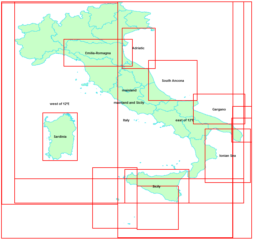
Supporting specific areas of use
|
PROJ.6 is now able to make a distinction between different areas of use within a CRS, and can eventually apply the most appropriate transformation when the intended area-of-use is explicitly specified, thus leading to more precise results. The side figure shows the situation for the Italian peninsula. As you can see there are two main areas (East and West of longitude 12E), but there are several smaller areas covering specific regions.
If your specific area of interest is contained within one of these sub-regions you can inform PROJ.6 which sub-region you want by giving either the area BBOX or name, and then PROJ.6 will attempt to use the most specific transformation parameters available. We'll examine this topic in more depth in the following sections. |
|
Concepts to keep well in mind
Additional conceptThe traditional spatial_ref_sys table contained within any SpatiaLite DB noticeably changes its intended purpose when using PROJ.6:
|
Transformation pipelines
There is a last astonishing innovation introduced in PROJ.6: transformation pipelines.When using a pipeline you can freely define any complex geodetic transformation by combining many elementary steps such as conversion, transformation, projection, axis swap and so on.
A pipeline is conceptually similar to a UNIX shell script, with a dataflow processing each step until the final result is produced.
The following is a practical example of a pipeline corresponding to a transformation from EPSG:4326 WGS 84 to EPSG:32632 WGS 84 / UTM zone 32N:
+proj=pipeline
+step +proj=axisswap +order=2,1
+step +proj=unitconvert +xy_in=deg +xy_out=rad
+step +proj=utm +zone=32 +ellps=WGS84
- Step 0: start a pipeline
- Step 1: switch the y,x based order to x,y
- Step 2: convert previous result from degrees to radians
- Step 3: convert previous result from WSG84 to UTM 32
|
Useful hint: PROJ.6 supports a new CLI tool (projinfo) for inspecting, in full detail, the internal definitions of CRSes, Transformations etc. The above pipeline is simply the output of the following command: projinfo -s EPSG:4326 -t EPSG:32632 -o projprojinfo is a very usefull resource; don't hesitate to use it frequently in order to discover what's really being done in the background. It's the best and easiest way to fully understand what PROJ.6 really does. projinfo also gives good hints when problems exist. In this case PROJ_LIB was incorrectly set and the needed grid files could not be found: Grid BETA2007.gsb needed but not found on the system. Can be obtained from the proj-datumgrid package at https://download.osgeo.org/proj/proj-datumgrid-latest.zipIt not only tells you which grid-file is needed, but also where to get it. |
| In order to learn more about the many interesting and cool new features supported by PROJ.6 please consult the original PROJ documentation |
|---|
PROJ.6 support on SpatiaLite-5.0.0
Creating and populating the spatial_ref_sys metatable
There is no relevant change. As in all previous versions spatial_ref_sys will be automatically created and properly populate by calling the appropriate SQL function.
SELECT InitSpatialMetaData(1);
      or
SELECT InitSpatialMetaDataFull(1);
|
Please remember that now in SpatiaLite-5.0.0 InitSpatialMetaDataFull represents the preferred method for creating all metadata tables required by this version. InitSpatialMetaData is still maintained so to not break historical compatibility, but should no longer be used. |
The most relevant change is that different versions of SpatiaLite/PROJ will now behave in radically different ways, as summarized in the following cross-version compatibility table.
| SpatiaLite / PROJ version | Connected DB | Action |
|---|---|---|
| SpatiaLite-5 built on PROJ.6 | DB created by SpatiaLite-5 / PROJ.6 |
libspatialite-5 when built on PROJ.6 will always ignore both the proj-strings stored in column proj4text and the WKT definitions stored in column srtext. It will instead allow PROJ.6 to retrieve the needed CRS definitions contained in its own private database. Note that this applies indifferently to both legacy databases created by any previous version and most modern databases created by the latest version. |
| DB created by SpatiaLite-5 / PROJ.4 or by any previous version of SpatiaLite (< 5.0.0) |
||
| SpatiaLite-5 built on PROJ.4 or any previous version of SpatiaLite (< 5.0.0) |
DB created by SpatiaLite-5 / PROJ.6 |
When libspatialite (any version, including 5.0.0) that was not compiled against PROJ.6, then the traditional approach will be always applied, and each CRS will be consequently identified by its corresponding proj-string stored in column proj4text Note that even when PROJ.6 is not supported any version of SpatiaLite (including 5.0.0) can safely connect to any DB-file created by the most recent version created with full PROJ.6 support. |
| DB created by SpatiaLite-5 / PROJ.4 or by any previous version of SpatiaLite (< 5.0.0) |
Existing SQL functions affected by PROJ.6
| SQL Function | Extended signature | Behavior under PROJ.6 | ||
|---|---|---|---|---|
| ST_Transform() |
ST_Transform ( geom Geometry , newSrid Integer , area Geometry ) : Geometry ST_Transform ( geom Geometry , newSrid Integer , area Geometry , proj_string_from Text ) : Geometry ST_Transform ( geom Geometry , newSrid Integer , area Geometry , proj_string_from Text , proj_string_to Text ) : Geometry |
| ||
Notes
| ||||
A few practical SQL examples:
-- from EPSG:4326 to EPSG:3003 - default settings; ignoring spatialite_ref_sys and relying on PROJ.6 own private database
SELECT AsEWKT ( ST_Transform( MakePoint( 11.878056 , 43.463056 , 4326 ) , 3003 ));
-------------------------------------
SRID=3003;POINT(1732852.942716769 4816277.617690674)


-- from EPSG:4326 to EPSG:3003 - exactly the same as above, but this time in an explicit form
SELECT AsEWKT ( ST_Transform( MakePoint( 11.878056 , 43.463056, 4326 ) , 3003, NULL, 'EPSG:4326', 'EPSG:3003'));
-------------------------------------
SRID=3003;POINT(1732852.942716769 4816277.617690674)


-- from EPSG:4326 to EPSG:3003 - same as above, using the alternative notation
SELECT AsEWKT ( ST_Transform( MakePoint( 11.878056 , 43.463056, 4326 ) , 3003, NULL, 'urn:ogc:def:crs:EPSG::4326', 'urn:ogc:def:crs:EPSG::3003'));
-------------------------------------
SRID=3003;POINT(1732852.942716769 4816277.617690674)


-- from EPSG:4326 to EPSG:3003 - explicitly passing CRS names
SELECT AsEWKT ( ST_Transform( MakePoint( 11.878056 , 43.463056, 4326 ) , 3003, NULL, 'WGS 84', 'Monte Mario / Italy zone 1'));
-------------------------------------
SRID=3003;POINT(1732852.942716769 4816277.617690674)


-- from EPSG:4326 to EPSG:3003 - simulating the classic PROJ.4 approach based on proj-strings stored into spatial_ref_sys
SELECT AsEWKT ( ST_Transform( MakePoint( 11.878056 , 43.463056, 4326 ) , 3003 , NULL ,
  (SELECT proj4text FROM spatial_ref_sys WHERE srid = 4326),
  (SELECT proj4text FROM spatial_ref_sys WHERE srid = 3003)));
-------------------------------------
SRID=3003;POINT(1732852.942716769 4816277.617690674)


-- from EPSG:4326 to EPSG:3003 - fancy mode based on WKT expressions stored into spatial_ref_sys
SELECT AsEWKT ( ST_Transform( MakePoint( 11.878056 , 43.463056, 4326 ) , 3003, NULL,
  (SELECT srtext FROM spatial_ref_sys WHERE srid = 4326),
  (SELECT srtext FROM spatial_ref_sys WHERE srid = 3003)));
-------------------------------------
SRID=3003;POINT(1732852.942716769 4816277.617690674)
This first test is based on a new SpatiaLite database created with full PROJ.6 support. Nothing special here other that all methods return the same results.
-- from EPSG:4326 to EPSG:3003 - using a transformation pipeline
SELECT AsEWKT ( ST_Transform( SwapCoords ( MakePoint( 11.878056 , 43.463056, 4326 ) ) , 3003 , NULL ,
'+proj=pipeline
+step +proj=axisswap +order=2,1
+step +proj=unitconvert +xy_in=deg +xy_out=rad
+step +proj=push +v_3
+step +proj=cart +ellps=WGS84
+step +inv +proj=helmert +x=-104.1 +y=-49.1 +z=-9.9 +rx=0.971 +ry=-2.917 +rz=0.714 +s=-11.68 +convention=position_vector
+step +inv +proj=cart +ellps=intl
+step +proj=pop +v_3
+step +proj=tmerc +lat_0=0 +lon_0=9 +k=0.9996 +x_0=1500000 +y_0=0 +ellps=intl' ));
-------------------------------------
SRID=3003;POINT(1732852.942716769 4816277.617690674)


-- from EPSG:4326 to EPSG:3003 - using a customized transformation pipeline
SELECT AsEWKT ( ST_Transform( MakePoint( 11.878056 , 43.463056, 4326 ) , 3003 , NULL ,
'+proj=pipeline
+step +proj=unitconvert +xy_in=deg +xy_out=rad
+step +proj=push +v_3
+step +proj=cart +ellps=WGS84
+step +inv +proj=helmert +x=-104.1 +y=-49.1 +z=-9.9 +rx=0.971 +ry=-2.917 +rz=0.714 +s=-11.68 +convention=position_vector
+step +inv +proj=cart +ellps=intl
+step +proj=pop +v_3
+step +proj=tmerc +lat_0=0 +lon_0=9 +k=0.9996 +x_0=1500000 +y_0=0 +ellps=intl' ));
-------------------------------------
SRID=3003;POINT(1732852.942716769 4816277.617690674)
This second test is based on using transformation pipelines:
- the first query directly uses a canonical string representing the pipeline as returning by this command executed from the shell:
projinfo -s EPSG:4326 -t EPSG:3003 --area "Italy - mainland" -o proj
(we'll see this topic in more depth on the next section). - the second query is just a small adaptation of the first one:
- As you can notice the first query requires calling SwapCoodinates() because the first step of the pipeline has an axisswap directive.
- The second query just avoids to call SwapCoords() and consequently this first step has been removed from the pipeline so to get the same identical overall effect.
- Note: SpatiaLite and PROJ.6 will always attempt to determine if swapping the coordinates is required or not.
But in the specific case of transformation pipelines the user is expected to explicitly call SwapCoords() whenever required.
Tech Note: using projinfo for discovering pipelines and areas of useprojinfo -s EPSG:4326 -t EPSG:3003 -o proj --spatial-test intersect Candidate operations found: 3 ------------------------------------- Operation n°1: unknown id, Inverse of Monte Mario to WGS 84 (4) + Italy zone 1, 4 m, Italy - mainland PROJ string: +proj=pipeline +step +proj=axisswap +order=2,1 +step +proj=unitconvert +xy_in=deg +xy_out=rad +step +proj=push +v_3 +step +proj=cart +ellps=WGS84 +step +inv +proj=helmert +x=-104.1 +y=-49.1 +z=-9.9 +rx=0.971 +ry=-2.917 +rz=0.714 +s=-11.68 +convention=position_vector +step +inv +proj=cart +ellps=intl +step +proj=pop +v_3 +step +proj=tmerc +lat_0=0 +lon_0=9 +k=0.9996 +x_0=1500000 +y_0=0 +ellps=intl ------------------------------------- Operation n°2: unknown id, Inverse of Monte Mario to WGS 84 (2) + Italy zone 1, 4 m, Italy - Sardinia onshore PROJ string: +proj=pipeline +step +proj=axisswap +order=2,1 +step +proj=unitconvert +xy_in=deg +xy_out=rad +step +proj=push +v_3 +step +proj=cart +ellps=WGS84 +step +inv +proj=helmert +x=-168.6 +y=-34 +z=38.6 +rx=-0.374 +ry=-0.679 +rz=-1.379 +s=-9.48 +convention=position_vector +step +inv +proj=cart +ellps=intl +step +proj=pop +v_3 +step +proj=tmerc +lat_0=0 +lon_0=9 +k=0.9996 +x_0=1500000 +y_0=0 +ellps=intl ------------------------------------- Operation n°3: unknown id, Inverse of Monte Mario to WGS 84 (11) + Italy zone 1, 10 m, Italy - Sicily Strait west of 13°E PROJ string: +proj=pipeline +step +proj=axisswap +order=2,1 +step +proj=unitconvert +xy_in=deg +xy_out=rad +step +proj=push +v_3 +step +proj=cart +ellps=WGS84 +step +proj=helmert +x=230.47 +y=56.08 +z=-22.43 +step +inv +proj=cart +ellps=intl +step +proj=pop +v_3 +step +proj=tmerc +lat_0=0 +lon_0=9 +k=0.9996 +x_0=1500000 +y_0=0 +ellps=intl |
-- from EPSG:426 to EPSG:3003 - default settings, NULL area of use
SELECT AsEWKT ( ST_Transform( MakePoint( 9.169464, 39.478275, 4326 ), 3003 ));
-------------------------------------
SRID=3003;POINT(1514600.134321862 4369874.489269957)


-- from EPSG:426 to EPSG:3003 - default settings, but this time explicitly defining the MBR aka BBOX of a specific area of use
SELECT AsEWKT ( ST_Transform( MakePoint( 9.169464, 39.478275, 4326 ), 3003 , BuildMBR(9.1 , 39.4 , 9.2 , 39.5 , 4326 )));
-------------------------------------
SRID=3003;POINT(1514605.982762248 4369873.004226943)
Third and final example. In some cases explicitly defining a specific area of use may enable PROJ.6 to select an optimized transformation leading to more precise results.
In this example we've used a Point located in Sardinia, and PROJ.6 supports several flavors of EPSG:3003 depending on the specific area of use and Italy - Sardinia onshore is one between them.
- the first query does not define any specific area of use, and consequently PROJ.6 calculated the transformation by applying the generic parameters supporting Italy - Mainland.
- the second query instead defines a specific are of use, and this time PROJ.6 calculated the transformation by applying the most precise parameters supporting Italy - Sardinia onshore.
Lesson learned:
|
New auxiliary SQL functions specifically supporting PROJ.6
| SQL Function | Supported arguments | Description |
|---|---|---|
| HasProj6( void ) : Boolean | None | Will return 1 (TRUE) if the library has been built with PROJ.6 (or any later version), otherwise 0 (FALSE). |
| PROJ_GetLastErrorMsg( void ) : String | None | Will return the most recent error message returned by PROJ (if any). NULL will be returned if there is no currently pending PROJ error. |
| PROJ_GetDatabasePath( void : String) | None | Will return the currently set pathname leading to the private PROJ's SQLite database. NULL will be returned if there is no private PROJ's SQLite database currently connected. |
| PROJ_SetDatabasePath ( new_path String ) : String |
|
Will change the currently set pathname leading to the private PROJ's SQLite database. NULL will be returned if the passed path is invalid, otherwise the path of the currently set private PROJ's SQLite database will be returned. |
| PROJ_AsProjString ( auth_name String , auth_srid Integer ) : String |
|
Will return the WKT expression corresponding to a given CRS; the definitions will be taken directly from the private PROJ's own database. NULL will be returned on failure or on invalid arguments. |
| PROJ_AsWKT ( auth_name String , auth_srid Integer ) : String PROJ_AsWKT ( auth_name String , auth_srid Integer , wkt_style String ) : String PROJ_AsWKT ( auth_name String , auth_srid Integer , wkt_style String , indented Boolean ) : String PROJ_AsWKT ( auth_name String , auth_srid Integer , wkt_style String , indented Boolean , indentation Integer ) : String |
|
Will return the WKT expression corresponding to a given CRS; the definitions will be taken directly from the private PROJ's own database. NULL will be returned on failure or on invalid arguments. |
| PROJ_GuessSridFromWKT ( wkt_expr String ) : Integer |
|
Will possibly return the SRID value corresponding to a given WKT expression defining a CRS. -1 will be returned if no CRS supported by PROJ.6 matches the WKT expression. NULL will be returned on invalid argument. |
| PROJ_GuessSridFromSHP ( filename String ) : Integer |
|
Will possibly return the SRID value corresponding to the CRS defined by the .PRJ member of the Shapefile. -1 will be returned if no CRS supported by PROJ.6 matches PRJ member of the Shapefile. NULL will be returned on invalid argument. Please note well: this SQL function opens the door to many potential security issues, and thus is always disabled by default. Explicitly setting the environment variable SPATIALITE_SECURITY=relaxed is absolutely required in order to enable this function. |
|
Note: all the above SQL Functions will be available only when Spatialite-5.0.0 has been built against PROJ.6 (or any subsequent version). If SpatiaLite-5.0.0 has been built instead against any previous version (as e.g. PROJ.4) any attempt to call one of these SQL Functions will simply return a no such function SQL error. |
Practical examples:
SELECT PROJ_GetDatabasePath();  -- retrieving the currently set PROJ's own database
------------------------------
/usr/local/share/proj/proj.db


SELECT PROJ_SetDatabasePath('/home/sandro/not_existing_proj.db'); -- non existing database
------------------------------
NULL


SELECT PROJ_GetLastErrorMsg(); -- retrieving the failure cause
------------------------------
proj_context_set_database_path: Open of /home/sandro/not_existing_proj.db failed


SELECT PROJ_SetDatabasePath('/home/sandro/valid_proj.db'); -- valid database
------------------------------
/home/sandro/valid_proj.db


SELECT PROJ_AsProjString('EPSG', 32632);
------------------------------
+proj=utm +zone=32 +datum=WGS84 +units=m +no_defs +type=crs


SELECT PROJ_AsWKT('EPSG', 4326); -- default settings: ISO-2018 style, indented with indentation 4
------------------------------
GEODCRS["WGS 84",
    DATUM["World Geodetic System 1984",
        ELLIPSOID["WGS 84",6378137,298.257223563,
            LENGTHUNIT["metre",1]]],
    PRIMEM["Greenwich",0,
        ANGLEUNIT["degree",0.0174532925199433]],
    CS[ellipsoidal,2],
        AXIS["geodetic latitude (Lat)",north,
            ORDER[1],
            ANGLEUNIT["degree",0.0174532925199433]],
        AXIS["geodetic longitude (Lon)",east,
            ORDER[2],
            ANGLEUNIT["degree",0.0174532925199433]],
    AREA["World"],
    BBOX[-90,-180,90,180],
    ID["EPSG",4326]]


SELECT PROJ_AsWKT('EPSG', 4326, 'ESRI', 0, 0); -- ESRI style, monolithic line
------------------------------
GEOGCS["GCS_WGS_1984",DATUM["D_WGS_1984",SPHEROID["WGS_1984",6378137.0,298.257223563]],PRIMEM["Greenwich",0.0],UNIT["Degree",0.0174532925199433]]


SELECT PROJ_GuessSridFromWKT('GEOGCS["GCS_Monte_Mario_Rome",DATUM["D_Monte_Mario",SPHEROID["International_1924",6378388.0,297.0]],PRIMEM["Rome",12.4523333333333],UNIT["Degree",0.0174532925199433]]');
------------------------------
4806


SELECT PROJ_GuessSridFromSHP('/home/sandro/tuscany_shp/prov2011'); -- remember: requires to explicitly set SPATIALITE_SECURITY=relaxed
------------------------------
3003
Important notice for Windows users |
|---|
|
PROJ.6 critically depends on its own private SQLite database (proj.db) containing all relevant definitions about Ellipsoids, Prime Meridians, CRSes, Transformations and alike. If PROJ.6 is unable to correctly establish a connection to this database it will be severely limited and will not be able to correctly behave as expected.
This isn't usually a big issue on Linux and Unix-like platforms, where a rational and very clear filesystem layout exists. On these operating systems the package manager (or make install) will automatically take care to install proj.db on the most appropriate directory (usually as /usr/share/proj/proj.db or as /usr/local/share/proj/proj.db) and that's all. Things are unhappily a little bit more difficult on Windows platforms. The user itself is responsible for properly installing proj.db So it becomes critical understanding the basic rules adopted by libspatialite in order to properly locate proj.db on Windows. |
Where proj.db is expected to be found on Windows |
An useful diagnostic checkSELECT PROJ_GetDatabasePath();
|
Using the environment variable PROJ_LIB |
|---|
PROJ_LIB is a standard environment variable supported by PROJ itself.
When PROJ_LIB is set, then PROJ.6 will directly use its own private database (and when needed any grids) in the directory referenced by the variable. Such a capability is supported on both Windows and Linux (and on any other platform). Linux example:
Windows example:
|
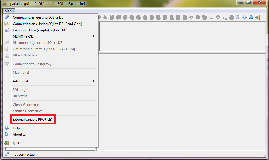
PROJ.6 support on spatialite_gui
|
The GUI tool now contains a new feature intended to make it as easy as possible to set PROJ_LIB used by PROJ.6 The main menu now contains an External variable PROJ_LIB item. After activating the corresponding option a standard File Selection Dialog will be shown, thus enabling the user to locate the private proj.db database of PROJ.6 in the file-system. Once the proj.db has been correctly located, spatialite_gui will automatically set the PROJ_LIB variable. And that's not all; spatialite_gui will read the current value of PROJ_LIB when started, so that will be a one time affair. |
|
|
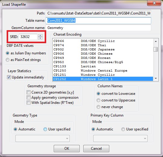
There is a further enhancement available when spatialite_gui is using PROJ.6 It's a very little evident innovation, but it will probably be highly appreciated by many users. When loading a Shapefile, the appropriate SRID value will be automatically determined by examining the content of the companion .prj file (if it exists). |
|
back