
More about Spatial SQL: WKT and WKB
Note: these pages are no longer maintainedNever the less, much of the information is still relevant.Beware, however, that some of the command syntax is from older versions, and thus may no longer work as expected. Also: external links, from external sources, inside these pages may no longer function. |
|
More about Spatial SQL: WKT and WKB |
| 2011 January 28 |
| Previous Slide | Table of Contents | Next Slide |
|
SpatiaLite supports a Geometry
data type conformant to the international standard OGC-SFS
(Open Geospatial Consortium - Simple Feature SQL). http://www.opengeospatial.org/standards/sfs Geometry is an abstract data type with seven related concrete sub-classes. You cannot directly instantiate a Geometry (because this one is and abstract class, and doesn't corresponds to any actual implementation): but you can freely instantiate any related sub-class. |
| Sub-Class | Example |
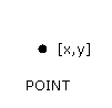
| POINT |
|
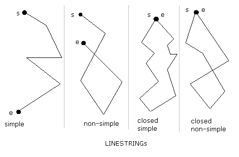
| LINESTRING |
|
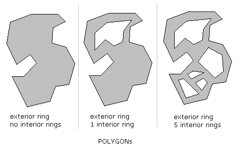
| POLYGON |
|
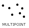
| MULTIPOINT |
|
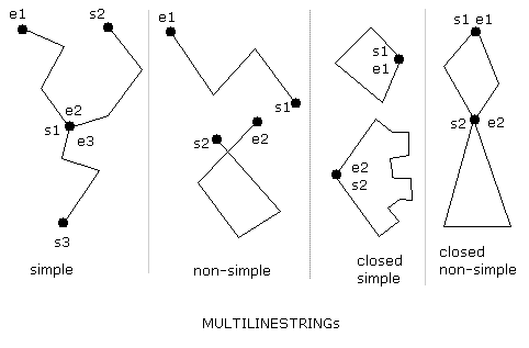
| MULTILINESTRING |
|
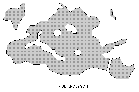
| MULTIPOLYGON |
|
| GEOMETRYCOLLECTION |
Any arbitrary collection of elementary sub-classes.
Please note: for some odd reason this one seems to be the sub-class absolutely beloved by inexperienced beginners: all them are fond of GEOMETRYCOLLECTION:
|
|
WKT and WKT notations Geometry is a very complex data type: accordingly to this, OGC-SFS defines two alternative standard notations allowing to represent Geometry values:
|
| Geometry Type | WKT example |
| POINT | POINT(123.45 543.21) |
| LINESTRING |
LINESTRING(100.0 200.0, 201.5 102.5, 1234.56 123.89)
three vertices |
| POLYGON |
POLYGON((101.23 171.82, 201.32 101.5, 215.7 201.953, 101.23 171.82))
exterior ring, no interior rings POLYGON((10 10, 20 10, 20 20, 10 20, 10 10), (13 13, 17 13, 17 17, 13 17, 13 13)) exterior ring, one interior ring |
| MULTIPOINT |
MULTIPOINT(1234.56 6543.21, 1 2, 3 4, 65.21 124.78)
three points |
| MULTILINESTRING |
MULTILINESTRING((1 2, 3 4), (5 6, 7 8, 9 10), (11 12, 13 14))
first and last linestrings have 2 vertices each one; the second linestring has 3 vertices |
| MULTIPOLYGON |
MULTIPOLYGON(((0 0,10 20,30 40,0 0),(1 1,2 2,3 3,1 1)), ((100 100,110 110,120 120,100 100))) two polygons: the first one has an interior ring |
| GEOMETRYCOLLECTION |
GEOMETRYCOLLECTION(POINT(1 1), LINESTRING(4 5, 6 7, 8 9), POINT(30 30)) |
| Geometry Type | WKT example |
| POINT | POINTZ(13.21 47.21 0.21) |
| LINESTRING | LINESTRINGZ(15.21 57.58 0.31, 15.81 57.12 0.33) |
| POLYGON | ... |
| MULTIPOINT | MULTIPOINTZ(15.21 57.58 0.31, 15.81 57.12 0.33) |
| MULTILINESTRING | ... |
| MULTIPOLYGON | ... |
| GEOMETRYCOLLECTION |
GEOMETRYCOLLECTIONZ(POINTZ(13.21 47.21 0.21), LINESTRINGZ(15.21 57.58 0.31, 15.81 57.12 0.33)) |
| Geometry Type | WKT example |
| POINT | POINTM(13.21 47.21 1000.0) |
| LINESTRING | LINESTRINGM(15.21 57.58 1000.0, 15.81 57.12 1100.0) |
| POLYGON | ... |
| MULTIPOINT | MULTIPOINTM(15.21 57.58 1000.0, 15.81 57.12 1100.0) |
| MULTILINESTRING | ... |
| MULTIPOLYGON | ... |
| GEOMETRYCOLLECTION |
GEOMETRYCOLLECTIONM(POINTM(13.21 47.21 1000.0), LINESTRINGM(15.21 57.58 1000.0, 15.81 57.12 1100.0)) |
| Geometry Type | WKT example |
| POINT | POINTZM(13.21 47.21 0.21 1000.0) |
| LINESTRING | LINESTRINGZM(15.21 57.58 0.31 1000.0, 15.81 57.12 0.33 1100.0) |
| POLYGON | ... |
| MULTIPOINT | MULTIPOINTZM(15.21 57.58 0.31 1000.0, 15.81 57.12 0.33 1100.0) |
| MULTILINESTRING | ... |
| MULTIPOLYGON | ... |
| GEOMETRYCOLLECTION |
GEOMETRYCOLLECTIONZM(POINTZM(13.21 47.21 0.21 1000.0), LINESTRINGZM(15.21 57.58 0.31 1000.0, 15.81 57.12 0.33 1100.0)) |
|
There are several Spatial SQL functions supporting
WKT and WKB
handling; examining all them one by one will surely be absolutely boring (and not really useful for the average user). So we'll briefly explore just the main (and most often used) ones. |
| SELECT Hex(ST_GeomFromText('POINT(1.2345 2.3456)')); |
| 0001FFFFFFFF8D976E1283C0F33F16FBCBEEC9C302408D976E1283C0F33F16FBCBEEC9C302407C010000008D976E1283C0F33F16FBCBEEC9C30240FE |
| SELECT ST_AsText(x'0001FFFFFFFF8D976E1283C0F33F16FBCBEEC9C302408D976E1283C0F33F16FBCBEEC9C302407C010000008D976E1283C0F33F16FBCBEEC9C30240FE'); |
| POINT(1.2345 2.3456) |
| SELECT Hex(ST_AsBinary(x'0001FFFFFFFF8D976E1283C0F33F16FBCBEEC9C302408D976E1283C0F33F16FBCBEEC9C302407C010000008D976E1283C0F33F16FBCBEEC9C30240FE')); |
| 01010000008D976E1283C0F33F16FBCBEEC9C30240 |
| SELECT Hex(ST_AsBinary(ST_GeomFromText('POINT(1.2345 2.3456)'))); |
| 01010000008D976E1283C0F33F16FBCBEEC9C30240 |
| SELECT ST_AsText(ST_GeomFromWKB(x'01010000008D976E1283C0F33F16FBCBEEC9C30240')); |
| POINT(1.2345 2.3456) |
| SELECT ST_GeometryType(ST_GeomFromText('POINT(1.2345 2.3456)')); |
| POINT |
| SELECT ST_GeometryType(ST_GeomFromText('POINTZ(1.2345 2.3456 10)')); |
| POINT Z |
| SELECT ST_GeometryType(ST_GeomFromText('POINT ZM(1.2345 2.3456 10 20)')); |
| POINT ZM |
| SELECT ST_Srid(ST_GeomFromText('POINT(1.2345 2.3456)')); |
| -1 |
| SELECT ST_Srid(ST_GeomFromText('POINT(1.2345 2.3456)', 4326)); |
| 4326 |
|
Common pitfalls "I've declared a MULTIPOINT-type Geometry column;now I absolutely have to insert a simple POINT into this table, but I get a constraint failed error ..." Any MULTIxxxxx type can store a single elementary item: you simply have to use the appropriate WKT syntax. And anyway several useful type casting functions exist. |
| SELECT ST_GeometryType(ST_GeomFromText('MULTIPOINT(1.2345 2.3456)')); |
| MULTIPOINT |
| SELECT ST_AsText(CastToMultiLineString(ST_GeomFromText('LINESTRING(1.2345 2.3456, 12.3456 23.4567)'))); |
| MULTILINESTRING((1.2345 2.3456, 12.3456 23.4567)) |
| SELECT ST_AsText(CastToXYZM(ST_GeomFromText('POINT(1.2345 2.3456)'))); |
| POINT ZM(1.2345 2.3456 0 0) |
| SELECT ST_AsText(CastToXY(ST_GeomFromText('POINT ZM(1.2345 2.3456 10 20)'))); |
| POINT(1.2345 2.3456) |
| Previous Slide | Table of Contents | Next Slide |

| Author: Alessandro Furieri a.furieri@lqt.it |
| This work is licensed under the Attribution-ShareAlike 3.0 Unported (CC BY-SA 3.0) license. | |
 |
Permission is granted to copy, distribute and/or modify this document under the terms of the GNU Free Documentation License, Version 1.3 or any later version published by the Free Software Foundation; with no Invariant Sections, no Front-Cover Texts, and no Back-Cover Texts. |